You can also listen to this article in the following audio:
In the ancient region of the Anahuac Valley, life flowed in harmony with the numerous lakes, ingenious chinampas, aqueducts and irrigation ditches that crisscrossed the landscape. However, with the arrival of the viceregal era, the city underwent profound and continuous environmental transformations that shaped its historical development and gave it many of the distinctive features that we can appreciate today.
The lake environment and pre-Hispanic hydraulic systems were gradually replaced by an urban infrastructure adapted to the new needs and visions of the novo-Hispanic society. These transcendental changes, although drastic, laid the foundations for the development of the modern metropolis, leaving an indelible mark on its physiognomy and character.
Cities and their environment
Cities do not emerge or develop in a vacuum, but are intrinsically linked to the natural environment that surrounds them. The geographic and environmental setting shapes all aspects of city life, from livelihoods to cultural expressions, as well as the economy, politics and worldview of its inhabitants.
Mexico City is a clear example of this interaction between the urban and the natural. Earthquakes, a recurrent phenomenon in this seismic region, have left a deep mark on its history. Some telluric movements have damaged emblematic buildings, forcing them to be rebuilt or adapted, as happened with the dome of the Santa Teresa temple in 1845 or the Angel of Independence sculpture in 1957.
On other occasions, earthquakes have acquired a symbolic meaning, such as that of June 7, 1911, seen as a harbinger of the political changes that were to come with the triumphal arrival of Francisco I. Madero to the capital. “The day Madero arrived, even the earth trembled”, it was said then, evidencing how natural phenomena interweave with social narratives.
But undoubtedly, the most devastating earthquake was that of September 19, 1985, which caused enormous material damage and human losses in the capital. Although tragic, this episode laid the foundations for a new culture of civil prevention, better construction standards and periodic drills.
Mexico City’s lake history also reflects this close relationship with its natural environment. The ancient Mexica knew how to take advantage of the basin’s resources and adapt to a constantly changing lagoon environment.
The Aquatic City: A Prodigy in the Waters
Upon arriving in the vicinity of ancient Tenochtitlan in November 1519, the eyes of Hernán Cortés and his men were filled with awe. Before them stood an unparalleled architectural marvel: a vast city built on the waters of two great lakes.
The Spaniards were dumbfounded when they contemplated the colossal dimensions of Huey altépetl. According to historian Serge Gruzinski, in 1520, with its three hundred thousand inhabitants, the Mexica city was probably the most populous in the world, surpassing even Constantinople and Paris.
But what most captivated the newcomers was the city’s lake-like condition. In his Second Letter of Relation, Cortés himself described with admiration the two lagoons that covered almost the entire territory, one of fresh water and the other, larger, of salt water.
An anonymous soldier who accompanied Cortés recorded in his chronicle the overwhelming impression the city made on the water: “The buildings there were so marvelous, and so admirable at the sight of its streets, squares and roads, both for the good order and manner in which it was built, as well as for being founded on water”.
Tenochtitlan, the lake jewel of the Mexica, left an indelible mark in the hearts and minds of the conquistadors, who witnessed a city without equal, defying the laws of nature and erecting its grandeur over the waters, one of the soldiers who accompanied Hernán Cortés commented.
This great city of Temistitan Messico is built within this part of the lake that has salt water, not in the middle, but at the edge of the water […] [Two of its causeways] cross the lake, enter through the middle of the city and there come together, so that they may be said to be one. The other causeway comes from the mainland to the city about a quarter of a league; [through this] comes a pipe or stream of water, from the mainland to the city, and it is sweet and very good; it is thicker than a man’s body and reaches the center of the town; all the neighbors drink from it, and it rises at the foot of a rock, on a hill, where a large fountain is made […].
This fragment provides an overview of the natural elements that defined the environment of these island communities. On the one hand, it highlights the presence of surrounding bodies of water, suggesting a maritime or lacustrine landscape. On the other hand, it indicates that the supply of drinking water came from an area located to the west, implying that the settlements depended on external sources to obtain this vital resource.
The great city Temistitan Messico had and has many and beautiful and wide streets, now that, outside of two or three main ones, all the others were half of land, like brickwork, and the other half of water, and they go out on the land part and on the other part of water in their boats and canoes, which are of a concave wood […]; there are many other main streets, which are all of water, which do not serve more than to transit in their boats and canoes […]. And in this way are all the other 12 towns that we have said, which are in this lake on the freshwater side.
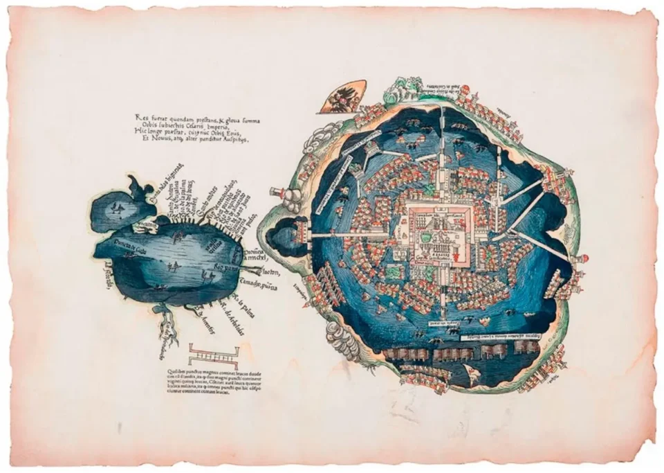
Apart from the written accounts, there is a visual testimony that shows the essentially lacustrine character of ancient Tenochtitlan. This is the so-called Nuremberg map, a woodcut published for the first time in 1524 in the German city that gives it its name, to accompany the narrative written by Cortés. It is the first cartographic representation of the city and, as Fabiola Ferman Cruz points out, this document “accurately reflects the vision that the indigenous population had of their city, but captured in the European artistic tradition”. It shows the center of Tenochtitlan, as well as other riverside towns located on the lakes, which determined the way of life of its inhabitants.
Drinking water supply and flooding
The inhabitants of ancient Tenochtitlan faced two fundamental challenges related to the aquatic environment surrounding the city. On the one hand, the constant threat of flooding due to its location in the middle of the lake. On the other hand, the pressing need to obtain fresh water suitable for human consumption, since much of the lake contained salt water near Texcoco, or fresh water contaminated with dense vegetation near Chalco and Xochimilco, making it undrinkable.
To solve the problem of water supply, the Mexica built aqueducts in different stages. One of these initiatives was undertaken by the tlatoani Chimalpopoca, who ordered the construction of an aqueduct to transport fresh water from Chapultepec. The first work was made of mud and wood. Later, another stone structure was built, taking advantage of the layout of the Tlacopan Causeway (now Tacuba Street), which began at the Palace of Axayácatl, where the Monte de Piedad building is located today, to the west of the Cathedral. According to Ángeles González Gamio, the change of location was due to the fact that the ground on this roadway was much firmer than on the road to Chapultepec.
These hydraulic works were engineering solutions to the challenges posed by Tenochtitlan’s lake environment, allowing its inhabitants to mitigate the risk of flooding and guarantee access to drinking water.
About the Chapultepec aqueduct, the chronicler Cer vantes de Salazar says the following:
…two pipes of earth, as strong as stone, so that the water never came except through one of the pipes, because when the one was dirty and muddy, they poured the water through the other, and thus the water ran clearer than crystal.
From this fountain […] all the principals were supplied; and from certain wooden pipes through which it ran over the irrigation ditches, many Indians collected the water in canoes, which they sold to others, and this was their deal, for which they paid certain fees to the great lord Moctezuma.
In the times of the Viceroyalty, and until the year 1896, during the Porfirian period, the construction of the aqueduct was resumed, extending towards the area of Arcos de Belen. That ancient aqueduct culminated with a sculptural fountain designed by Guillermo Ruiz, which is currently located in Tepoztlán. (The fountain that can be seen today in Salto del Agua is a replica).
In addition to the Chapultepec waterworks, during the government of Ahuízotl, the eighth Mexica sovereign, a second aqueduct called Acuecuéxcatl was built, fed by the springs of Coyoacán.
Fray Diego Durán speaks of this second aqueduct:
…they made a very strong dam of mortar for these springs, which, by violating the water, made it rise with great force, because they sent the best masters that were found in all the provinces, and so […] great masters and divers went down to the springs of water to clean and brighten them and to close all the drains and veins through which they drained.
Ahuízotl’s ambitious project to transport water to Tenochtitlán defied the warnings of Tzuzuma, the lord of Coyoacán. Despite concerns about the excessive flow and the risk of tragedy, the tlatoani proceeded with his plan. Unfortunately, the omen was fulfilled in 1499 when a flood indirectly claimed his life.
Flooding was a recurrent and severe problem, which led to the construction of albarradones to regulate lake levels. After a flood in 1450, Moctezuma I made the decision to erect a monumental albarradón that extended from Iztapalapa to Atzacualco. In this colossal work, he had the help of Nezahualcoyotl, the ruler and poet of Texcoco, which is why the imposing structure, twelve kilometers long and nearly twenty meters wide, was named after him.
In 1499 Tenochtitlan suffered a severe flood after the aqueduct carrying water from Coyoacán overflowed.
From the ancient water city to the lake drying up
In the viceregal era, Mexico City suffered numerous floods that left a deep mark. Although there were floods in the early years of New Spain, such as 1555 and 1580, the episodes intensified in the 17th century, with floods recorded in 1604, 1607, 1615 and 1623, among other dates. This situation continued during the 18th and 19th centuries.
However, the most devastating event was the flood of 1629, known as the “deluge of San Mateo”. On the night of September 21 of that year, an intense rain lashed the Novohispanic capital for approximately 36 uninterrupted hours. According to accounts of the time, the city was practically submerged, with a water level that reached a height of two meters in some places, as attested by a figure carved in stone in the shape of a feline face on the corner of present-day Madero and Motolinía streets.
The consequences were disastrous. Convents, civil buildings and the adobe constructions of the indigenous neighborhoods suffered serious damage. Movement was only possible in small canoes, and grain and cereal reserves were affected, causing corn shortages and speculation on the part of some Spanish traders. Embankments, wooden bridges and footbridges were improvised to facilitate pedestrian traffic, while masses were celebrated on the rooftops.
In an attempt to console the population, on September 24, a water procession was organized in canoes and trajineras, carrying the image of the Virgin of Guadalupe from Tepeyac to the Metropolitan Cathedral, accompanied by some two hundred small boats. The Virgin remained in the cathedral until five years later, when Archbishop Francisco Manzo ordered her return.
Meanwhile, water gradually diminished until a drought arrived in 1634, although not without leaving a tragic toll of approximately thirty thousand victims. In addition, the situation led to epidemic outbreaks, as had occurred in previous floods with cases of diarrhea, measles, yellow fever and black vomit, according to historical records.
The cosmographer Henrico Martínez, who had arrived in New Spain with Viceroy Luis de Velasco, witnessed the events:
While the rains were falling on September 21, St. Matthew’s Day, a dreadful downpour lasted thirty-six hours straight. The city was completely flooded. Only a part of the Palace, the archbishop’s houses, Santa Teresa Street and a part of the Plaza Mayor were spared from the furious onslaught of the waters […] the convents were abandoned, the churches were closed, commerce was paralyzed […]. Of twenty thousand Spanish families, only four hundred remained in the flooded city. The rest had fled to other cities and towns safe from the catastrophe, such as Puebla, Coyoacán, San Agustín de las Cuevas, Tacuba, Mexicaltzingo, Texcoco.
Despite his recognized work, Henrico Martínez also had his share of responsibility in the tragedy of the floods that devastated Mexico City. After the events of 1604 and 1607, the viceroyal authorities took up the old idea of draining Lake Texcoco and diverting the course of mighty rivers such as the Cuautitlán, in order to mitigate the risks. It was Martínez himself who conceived the solution of digging an open channel to conduct the waters of Zumpango towards Huehuetoca, in the direction of the waters of Tula, thus giving way to the drainage projects of the capital.
However, the road was plagued with obstacles. In 1627, the Cuautitlán River dam broke, causing the region’s lakes to overflow and flood. Martinez was widely criticized, and soon after, Adrian Boot proposed an alternative to “prevent the waters from damaging the city,” with the intention of restoring the pre-Hispanic lakes. However, Boot, being a Calvinist, was accused of heresy and had problems with the Holy Inquisition, which prevented his proposal from being considered, thus imposing Martinez’s plan.
In the following years, the progress of the works was intermittent, halted at times by various circumstances. One of the most pressing was in 1623, when the Viceroy Marquis of Gálvez arrived in New Spain and, in an excess of zeal for the care of the royal treasury, gave the order to suspend the drainage works.
This is how Baron Humboldt narrates it:
A new viceroy, the Marquis of Gelves, barely arrived in Mexico and without having witnessed the floods caused by the outflow of the Cuautitlan river, had the temerity to order the engineer Martinez to plug the tunnel and let in the water from the Cuautitlan river.
The waters of Zumpango and San Cristobal on Lake Texcoco, to see if the danger was indeed as great as it had been portrayed.
Efforts to drain Mexico City’s lake faced numerous challenges and setbacks. Work resumed in 1628, but the following year’s deluge further aggravated the situation. Henrico Martínez, in an attempt to protect the tunnel under construction, ordered the closure of the Zumpango canal, a decision that proved detrimental to the city and landed him in jail when he was accused of being responsible, according to historian Elisa Martínez Vega.
After these events, a plan was put into action to create an artificial drainage system to gradually reclaim the lake, thus beginning the long process of draining it. It was a gradual transformation, for although the lake was being drained, the city still retained its numerous canals for a long time, such as the Real, which ran along the south side of the palace where Corregidora Street passes today, or the San Francisco, on present-day Madero Street. However, these projects marked a point of no return, causing the most significant environmental change since the founding of Tenochtitlan. A transformation that not only defines us historically, but has determined to this day the way in which our city has been adapting.
XIKOOVA is a project inspired by the history of Mexico and the richness of its cultural diversity. It places particular emphasis on contemporary historical research that offers a novel approach to the historical understanding and anthropological evolution of the country's culture.