Upon arriving at the lake basin and in the various settlements they occupied for a century, the Aztecs carried out “religious constructions, acquired knowledge of water management through dams and erected defensive structures”, as Sonia Lombardo points out in her work “Urban Development of Mexico-Tenochtitlan”. Thus, when Tenochtitlan was founded in 1325 (some sources suggest 1370), on an islet in Lake Texcoco, they already had notions of urban planning and hydraulic engineering.
The longed-for sign, according to the legend, represented by an eagle (Huitzilopochtli) perched on a cactus, was spotted “on a small islet, surrounded by tules and reeds, which was part of the Tepaneca lordship governed by the powerful Tezozómoc”, as Lombardo indicates. According to the Codex Ramirez, quoted by the author, “the next day” they began the construction of an “altar of humiliation” to pay homage to the protector god, and “…using the sturdiest reeds they found in the reeds, they erected a square seat right in the same place…”. This site probably coincides with the present remains of the Templo Mayor.
Living space was extremely limited. They were in a situation of “scarcity, confinement and apprehension”, so that their first constructions were simply jacales made of reed. Their livelihood depended exclusively on fishing and the resources obtained from the lagoon.
In the second year, the Aztecs were able to acquire materials such as stone, wood and lime to erect a more durable temple in honor of Huitzilopochtli. This was achieved in exchange for resources from the lagoon: “…the fish, the salamander and the frog, the shrimp, the aneneztli, the water snake, the swamp mosquito, the lake worm and the duck, the cuauhchilli and the mallard, all the aquatic birds, with which we acquired the stone and the wood…”
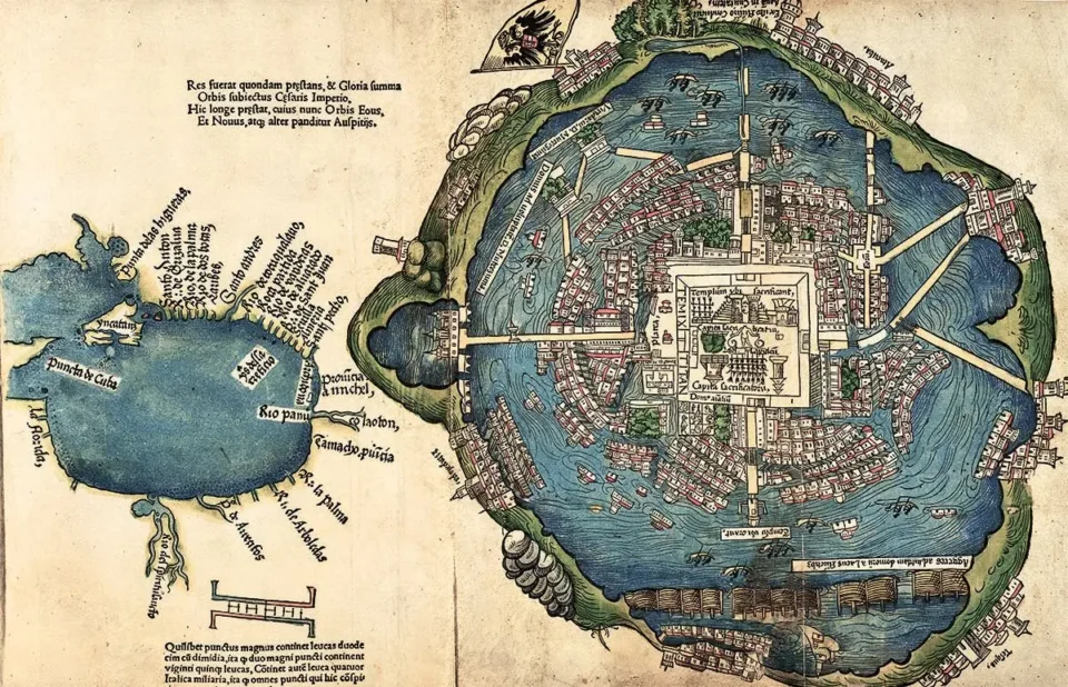
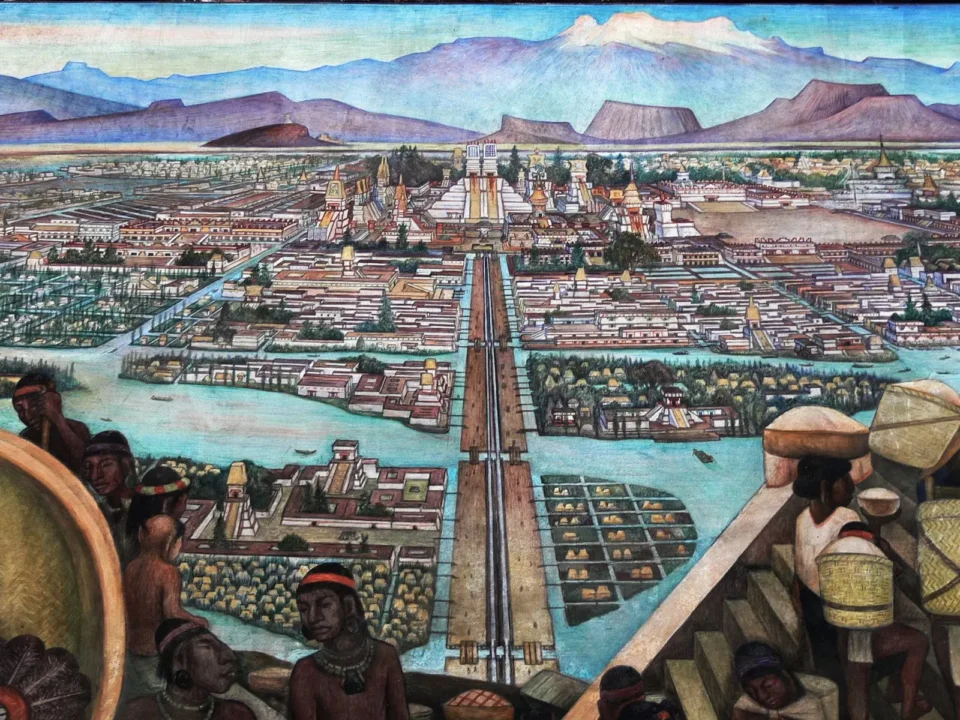
After the construction of the temple, a ball court was erected. The layout was radial, with four causeways radiating from the temple towards the cardinal points, thus forming four sectors. The lack of habitable space was solved by expanding the land, adding chinampas to the islet, especially in the south and southwest directions. The first main arteries were waterways, which made navigation a daily activity.
A very delicate water management system.
Expert understanding of the flow patterns in the surrounding bodies of water gave the Mexica the ability to establish a sophisticated hydraulic system based on dams, floodgates, irrigation ditches and a network of canals for both navigation and irrigation, thus forming a system that adjusted to the seasons of the year. This engineering not only mitigated the risk of flooding, but also prevented the mixing of the saline waters of Texcoco with the fresh waters of Xochimilco and Chalco, as well as preventing possible attacks from rival communities.
A clear example of this innovation is the Iztapalapa causeway, which served a dual function as an extensive dike separating saline and fresh waters. On both sides of this road, canals flowed that probably played a strategic role in the transport of resources. The relevance of this transportation infrastructure is reflected in “Historia general de la infantería de marina mexicana”, where it is suggested that it not only facilitated the transfer of supplies and personnel, but also conveyed the notion of the vulnerability of the lake cities and islands to a possible enemy attack. Tenochtitlán’s geographical position allowed the militias to move quickly through the basin.
“The Mexica military structure included an Infantry Corps, which operated both on land and in aquatic environments, covering rivers, lakes and coasts, manifesting a versatile approach in its organization.”
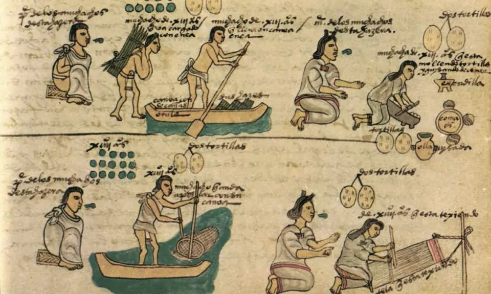
In terms of road infrastructure, the Tacuba causeway stands out, which apparently had at least seven drawbridges, and presumably followed a model similar to that of the Iztapalapa causeway, carrying out both aquatic and road functions. According to Lombardo’s writings, during the reign of Moctezuma II (1502-1520), the city had three types of streets: terrestrial, aquatic and mixed. The waterways were highly transited thanks to the canoes, used as an efficient and widespread method of communication among the population, while the chinampas and most of the houses connected with irrigation ditches for daily services. The main doors of the houses opened onto narrow land streets. Small beam bridges crossed the ditches, facilitating the passage of pedestrians.
Some of the mixed streets had a considerable width. Take as an example the road currently corresponding to 16 de Septiembre-Corregidora, later called Acequia and Las Canoas, which had a width of 7.5 meters in the water lane and 5 meters in the land lane.
The Mexica demonstrated outstanding control in the art of navigation and the science of hydraulic engineering. When the Spaniards arrived, the Valley was home to about 40 cities that maintained a vigorous activity. According to Carlos J. Sierra in “Historia de la navegación en la Ciudad de México”, it is estimated that, at the beginning of the 16th century, approximately one million fish were extracted to supply these cities. Every day, some 4,000 canoes entered the city bound for the Tlatelolco market. Alonso Suaro, another Spanish chronicler, calculated that in the lagoon there were between “sixty and seventy thousand large canoes” used to transport provisions.
Although there is no confirmation in the sources consulted, it has been mentioned that the Mexica practiced a form of sport similar to regattas as part of their training.
Regarding the acallis, a term used to refer to smaller vessels, Gonzalo Fernández de Oviedo, one of the conquistadors, described that “they were carved from a single tree trunk without joints (…). They had a flat bottom and no keel. There were various sizes, from one or two persons to those that could carry forty or fifty crew members. They were very light and capsized easily, but did not sink, even if filled with water.” Poles were used in shallow water to propel the boat, while paddle oars were used in deeper water.
mixed infantry controlling the lakes.
In its beginnings, Mexica society was characterized as theocratic, with leadership led by religious figures. However, over time, this structure evolved into an imperial system in which commercial and military aspects became as important as religion.
This change developed gradually, but the rise of the Mexica as a dominant culture in Mesoamerica was solidified with the formation of the Triple Alliance in 1430, in collaboration with Texcoco and Tlacopan.
At the height of what could be described as a “militaristic state” formed by the Triple Alliance, navigation acquired a strategic role, since its power was based on the extensive use of canoes. These vessels offered benefits in the transport of military supplies, soldiers and equipment. In addition, they contributed to propagate the perception, both among the lake cities and the islands, that they were targets that could be reached quickly. These aspects are highlighted in “Historia general de la infantería de marina mexicana”.
Tenochtitlán’s location gave the militias the ability to move quickly throughout the basin, which provided a crucial strategic advantage.
“Within their military structure, the Mexica had an Infantry Corps that operated not only on land, but also in river, lake and coastal environments. This meant that this infantry had versatility in both terrestrial and aquatic environments.”
In the context of Tenochtitlán, the route that currently corresponds to the 16 de Septiembre-Corregidora avenue had a hybrid nature. This road had a width of 7.5 meters in the water lane and 5 meters in the land lane.

Thirteen brigantines from Tlaxcala.
The vision the Spaniards had upon first contemplating the majesty of the city of Mexico-Tenochtitlan has been described on countless occasions; Bernal Díaz del Castillo expressed it as “… things of enchantment”. When invited to explore the city, both the lake structure and the naval activity attracted the attention of the conquistadors. Hernán Cortés carefully observed the operation of the floodgates and recognized the threat they would pose in future confrontations. In response, he planned the construction of “four brigantines to facilitate exit by water in case of need,” as chronicles of the time relate.
At the same time, Moctezuma II experienced for himself the amazement of boarding one of the brigantines, when he was invited to join a hunt. The technology of the sails, unknown to him, proved to be far superior to the indigenous canoes that could not catch up.
The first major clash between the Mexica and the Spanish, along with their indigenous allies, took place after the massacre at the Templo Mayor, in which 600 high-ranking Mexica were killed by Cortés’ soldiers. The indigenous retaliation ended on June 30, 1520, after seven days of siege against the foreigners, who took refuge in the houses of Axayácatl. The Spaniards fled silently during the night, along Tlacopan Avenue. However, they were discovered and attacked both through the irrigation ditches and from the rear with projectiles. Despite carrying a portable bridge to cross the sections cut by the irrigation ditches, many did not make it to the mainland and lost their lives in the attempt.
A year later, with the support of the Tlaxcalans, Cortés returned with the firm intention of conquering the city. His strategy involved encircling it and cutting off its provisions, especially the supply of drinking water that came through an aqueduct from Chapultepec. To confront the imperial naval fleet, he brought with him from Tlaxcala 13 brigantines that he had ordered to be built. These were transported by eight thousand Indians to Lake Texcoco. The first naval combat documented in the chronicles of the American continent was fought at 2,200 meters above sea level during the siege imposed by Cortés on the great Tenochtitlán in Lake Texcoco, beginning on May 10, 1521 and lasting 95 days, according to records in “Historia general de la infantería” (General History of the Infantry). Other sources suggest that its duration was 75 days.
Through alliances that were consolidated, Cortés finally achieved the conquest with the support of 50,000 indigenous combatants and 20,000 canoes. On the Mexica side, 300,000 troops and “thousands” of canoes participated, many of them with armor. Among their combat tactics, the Mexica installed stakes in the lake to damage enemy vessels or drove them to unseen areas called albarradones so that they would collide there. Some of the brigantines had to be repaired during the siege.
Meanwhile, land incursions became deeper as time went on. The supply of drinking water was soon exhausted and the solution of supplying it by canoes proved unsustainable. The cut-off of communication between Tenochtitlán and Tlatelolco, their source of provisions, proved crucial.
In the final battle, which lasted 24 hours, the Mexica faced both brigantines and 6,000 canoes. Finally, on August 13, Tenochtitlán, exhausted by war, hunger, thirst and smallpox, fell, as summarized in “Historia general”.
In later times, to the east of the city, a fortress known as Las Atarazanas was erected to guard the brigantines, guaranteeing their safety and their ability to enter and exit as needed. This site, close to La Merced market, evolved into a small square. However, lack of care, maintenance and careening led to the destruction of those ships between 1531 and 1540.
Solutions in the new Spain a vicious circle of patches
The capital of New Spain maintained in part the pre-Hispanic hydraulic system, although it suffered considerable damage during the siege. An example of this was the breaking of the albarrada de Netzahualcóyotl by Cortés, which had served to direct the flow of fresh water from springs and lakes such as Xochimilco and Tláhuac around the island. This breach was made to make way for the brigantines. After the war, many ditches were filled with stones from destroyed buildings, transforming them into streets and avenues.
Despite this, river navigation continued to be active, not only for supplies, but also for the construction of the new city. A large quantity of materials was transported in canoes. Curiously, several dams were altered by using their stones.
Subsequently, the intensity of water traffic decreased. According to Sierra, “during the years of the Conquest, the number of canoes oscillated between 100 and 200,000; in the 16th century, more than 1,000 canoes entered the city daily. However, by the 17th century, this figure varied between 70 and 150.
The disarticulation of the hydraulic system led to flooding problems which, in turn, made it difficult to clean the canals, generating a vicious circle. The flood of 1629, which submerged the city in water and mud for four years and forced evacuations, further aggravated the river system. For example, the albarrada de San Lázaro was completely covered by water.
These difficulties led the Spaniards to try to solve the problem by patching it up, but without success. By the end of the 16th century, the idea of draining the lake was already under consideration, although it would take centuries to carry it out.
Nevertheless, by the late 17th and early 18th centuries, travelers and chroniclers praised the “Venetian” image of the city. Despite the adversities, seven main irrigation ditches survived, along with several secondary ones, canals and bridges that fostered a vibrant commerce.
In fact, there was a resurgence in river trade. Each canoe could carry between 65 and 70 bushels of corn (a bushel was approximately 55 liters), according to Sierra. By the end of the 17th century, it was estimated that around 5,000 bushels were arriving in the city. In 1709, 97,330 bushels transported in 1,419 canoes were recorded. In addition, other products were also transported through this waterway.
In 1803-1804, Viceroy Iturrigaray made the decision to open the Texcoco canal in order to reduce the cost of transporting wheat from Tula and Cuatitlán. This was due to the high cost of overland freight. The dirt roads were at risk due to the presence of robbers and suffered deterioration during the rainy season, although the yield of the river canal decreased in times of drought.
Nevertheless, in a sort of institutional contradiction, the project to drain and drain the lakes continued. The arrival of the Bourbon dynasty to the Spanish throne marked the destiny of New Spain in economic, political, social and cultural terms. The system of irrigation ditches and canals also faced its definitive challenge.
Due to their limited efficiency as a means of transporting people and supplies… Bourbon reforms included a focus on the cleanliness and organization of the roads. Ditches were identified as “sources of infection”, but to ensure the drainage of the city, “the main ones (…) were replaced by subway conduits or atarjeas”.
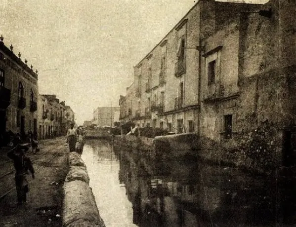
The process of obstructing the irrigation ditches began in 1753, starting with the blocking of the Royal Ditch, the most abundant of all: “…it was blocked in the section with the least river traffic, between the Coliseum and the southwest corner of the Plaza Mayor, and in its place a double ditch was built to ensure a smooth flow of water”.
By the beginning of the 19th century, “the ‘water streets’ had practically disappeared” from the urban structure. Of the 56 bridges that existed in the mid-18th century, about a dozen had been lost – the remaining ones deteriorated – although some new ones were also built.
A sad disassembly
The transformation of the old hydraulic system of Mexico-Tenochtitlan was methodically executed under the direction of the Bourbons. This change not only permanently altered the urban landscape, but also the means of transportation and points of reference for the inhabitants of the colonial city.
The progressive “obstruction of the irrigation ditches” began in the eighteenth century and continued throughout the nineteenth century, as detailed in the study “Las calles de agua de la Ciudad de México en los siglos XVIII y XIX” by Guadalupe de la Torre.
Several factors contributed to this process. The decrease in the water level in the acequias was due to “the detour of water flows and the expansion of riverbeds to expand irrigation of arable land”. In addition, “the lack of an effective strategy for the maintenance and cleaning of the irrigation ditches caused their deterioration”.
By the end of the 19th century, bridges were no longer predominant urban landmarks, although many streets still retained related names, such as Puente de la Misericordia, Puente de Tezontlale, Puente del Espíritu Santo or Puente del Zacate, as De la Torre points out.
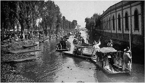
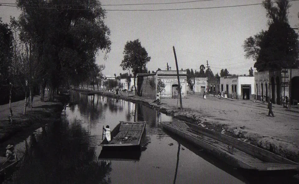
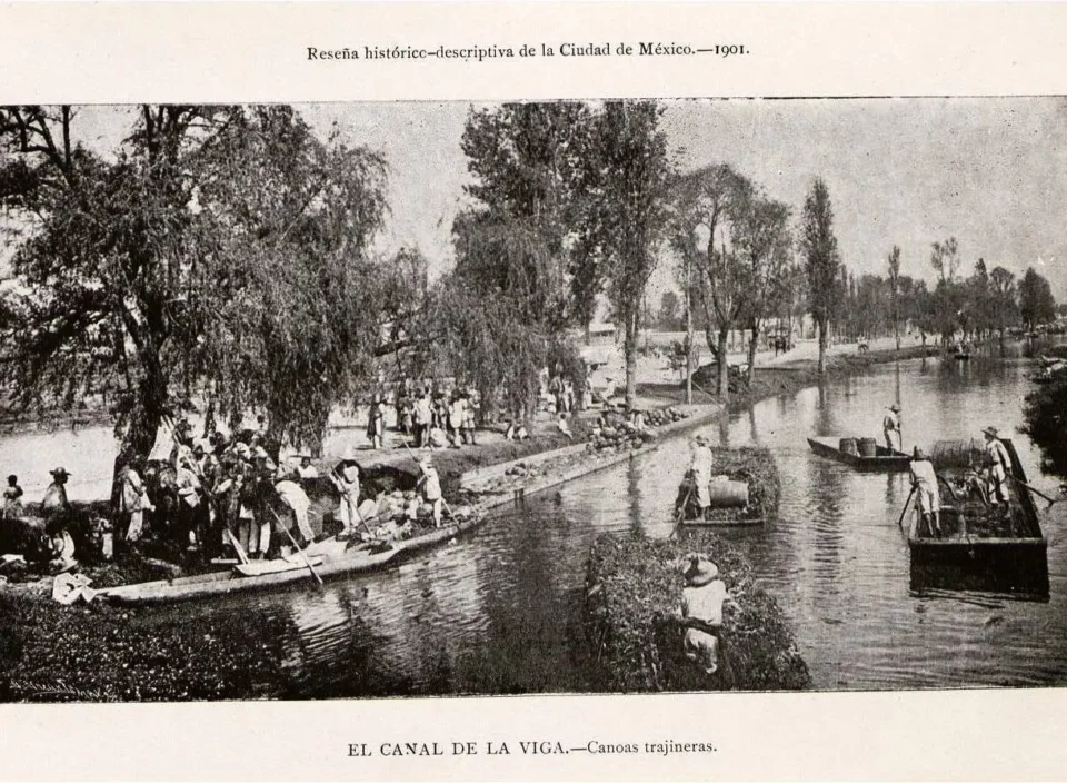
However, the Acequia de Mexicalzingo, also known as the Canal de La Viga, had a different destiny. Throughout the 18th century, the viceroyalty authorities were interested in keeping it functional to facilitate the traffic of canoes and trajineras. As the water level decreased due to the drying up of the lakes, floodgates were installed in Chalco to regulate its flow.
This canal even had an important bridge, La Viga, which since 1604 functioned as a checkpoint, located two kilometers from present-day San Pablo Street. In the 19th century, a wide variety of products transited through this canal, from foodstuffs such as sesame, rice and corn, to materials such as wood, beams, iron and more, as detailed in Araceli Peralta’s account in “El canal, puente y garita de la Viga” (The La Viga Canal, Bridge and Checkpoint).
In the period from 1858 to 1859, the La Viga checkpoint saw the passage of 685 trajineras, 960 larger boats (24 varas long), 90 medium-sized boats (12 varas long) and 458 chalupitas carrying wool, stone, sand and more, for a total of 4,944 canoes.
This busy commercial flow would join the new wave of industrial innovations.

The Mexican Republic on a steamboat
After the achievement of the War of Independence, the question of the lake system in the Valley of Mexico remained a controversial issue: “while some considered it essential to drain the lakes, others advocated taking advantage of them for transportation, canalization and irrigation purposes, and there were those who believed in the combination of both strategies for the planned development of Mexico City,” as Sierra’s opinion highlights.
Among the group of those interested in taking advantage of bodies of water were a number of entrepreneurs and inventors who, from the 1840s to the end of the century, presented a series of projects for inland navigation. The ability of many of these projects to prosper, despite the political and economic instability that characterized Mexico during much of that period, is surprising, although it is true that several also had unfavorable results.
The precursor of steam navigation on the Anahuac was Mariano Ayllón, who overcame multiple obstacles to establish and operate a company with three steamboats, destined to travel between the capital, Chalco, Texcoco, Tacubaya, Guadalupe Hidalgo, San Ángel and Tlalpan. This involved the construction of the first two steamboats (one with a capacity for 200 passengers and the other for 20), the creation of a dock at the La Viga checkpoint, the cleaning of the canal and the raising of some bridges. On July 21, 1850, the steamer Esperanza made its first trip to Chalco, and by August, the service was in regular operation.
In 1861, José Brunet also obtained permission to operate steamboats in the valley. In addition, Carlos Pehive introduced “propeller boats for the canal or ditch from Mexico to Tacubaya,” while Tito Rosas promoted sailing in sailboats. During the Maximilian government (1863-1867), as Sierra mentions, some additional permits were granted. In 1869, a company launched the steamship Gautimoc, which offered services between the city and lakeside towns. On its maiden voyage, President Juárez was invited and part of his cabinet was present. Although on the trip there was an explosion in the boiler, fortunately without causing any damage. Guillermo Prieto, in a chronicle, commented: “… the good fortune of the President of the Republic, who always comes out unscathed from all dangers, is striking”.
Approval of more projects continued until 1890. However, natural desiccation of the lakes persisted, and maintaining adequate water levels for navigation in the canals became increasingly challenging by the second half of the 19th century. Numerous steamboats operated in this period between the capital and Chalco.
Despite the need for works, the uncertainty as to whether accelerating the dewatering was the best option remained an unresolved issue. It was during Madero’s administration that the decision was finally made to carry out this task.
Last glimpses of a lake past.
The transformation of the lake system in Mexico City experienced its last phases at the end of the 19th century and at the dawn of the 20th century. The elements that contributed to this process are in essence similar to those that manifested themselves in the mid-18th century, but with an accentuated intensity. In addition, the rise of the railroad and later the automobile gradually displaced river transport.
After the drainage of the La Viga canal, this body of water became a deposit of waste and garbage, where elements such as water lilies, decomposing animals and various types of putrefied materials accumulated. This situation led the Hygiene Commission to classify this area as a high risk to public health. In 1940 the filling process began and by 1957 the area was paved, as detailed by Peralta.

One type of resurgence of the lake system took place in 1952, when floods caused considerable damage in the city center, especially on 16 de Septiembre Street. During this period, canoes reappeared “sporadically” to transport people, as Sierra points out. It seemed that the spirit of times past wished to remind the inhabitants of modern Mexico City of one of the means of transportation that was once essential in this region.
Some resuscitation maneuvers.
The discovery in 1978 of the monolith of the goddess Coyolxauhqui, belonging to the Mexica civilization, in the area of the Templo Mayor, provoked a notable interest on the part of the local and federal governments to revitalize the Historic Center of Mexico City, which had been neglected at the institutional level.
The initiative began with the demolition of structures in the region to recover pre-Hispanic vestiges. This process was followed by a kind of reconstruction of the colonial city, which involved the restoration of emblematic buildings and the recovery of the historical scale of the city.
The restoration project, carried out between 1980 and 1981, also included archaeological excavations on a 260-meter stretch of the Acequia Real, which ran along the streets of Corregidora, from Pino Suárez to Alhóndiga, and then following the latter. The Acequia Real, which was vital in pre-Hispanic times, had been partially obstructed at several points and its closure was completed in 1939.
These excavations made it possible to trace the route of the irrigation ditch and to discover the remains of walls, stairways, piers and bridges, as well as a variety of objects from both the pre-Hispanic and colonial eras.
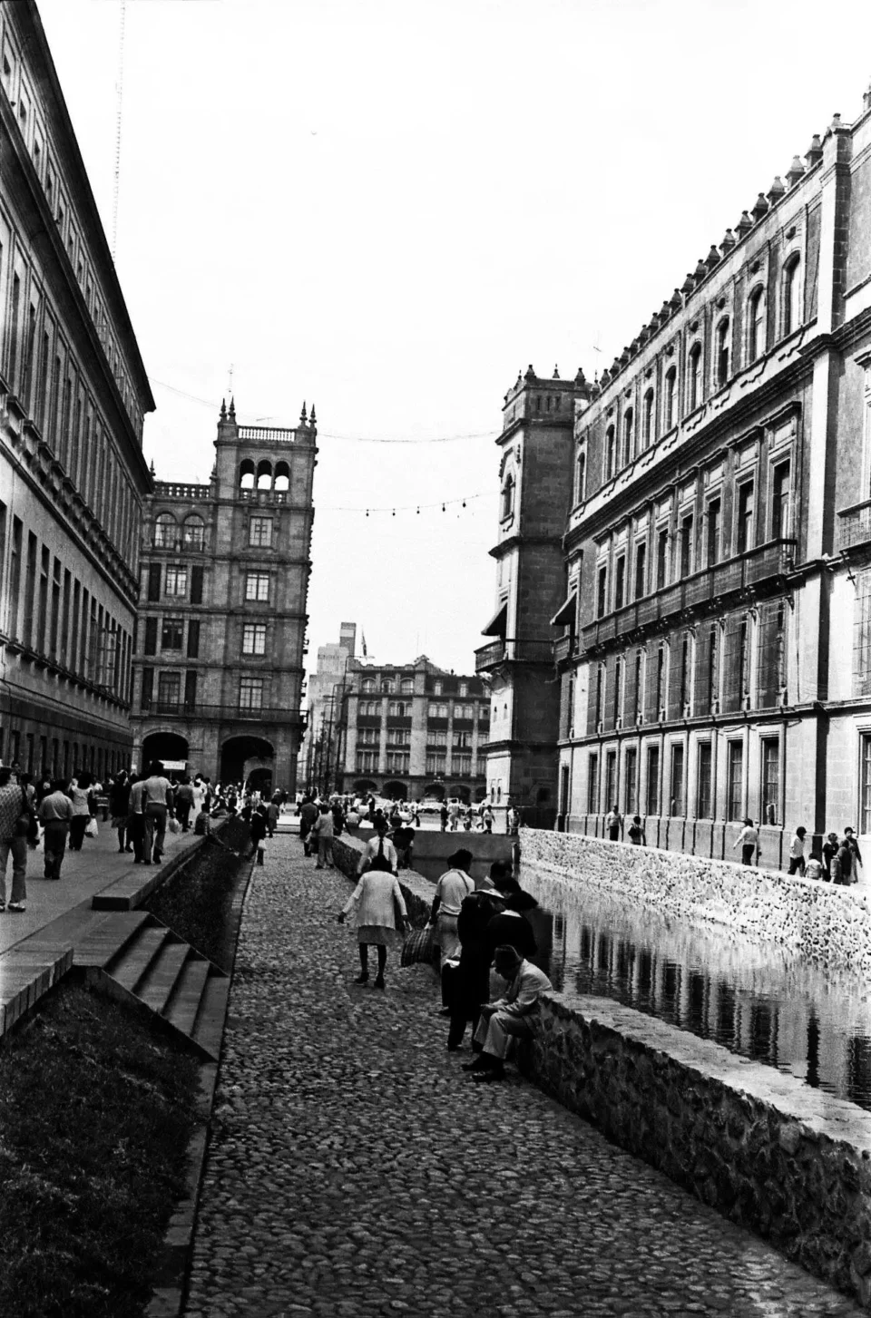
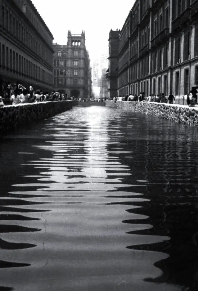
Under the direction of architects Pedro Ramírez Vázquez and Vicente Medel, together with historian Gastón García Cantú, it was decided to restore two sections of the Acequia. One of them was located in Corregidora, along the National Palace, and the other in Alhóndiga.
Images from that time show an unusual urban landscape with these two restored water areas. However, this was also a time of rapid growth of informal commerce, which led to the encroachment of the streets. The restored sections were hidden and became garbage dumps, repeating a pattern of decay. In 2004, these sections had to be closed again.
For a time, puddles formed under the Roldán bridge and near the Casa del Diezmo. These problems were addressed in 2009, when a renovation of the urban infrastructure of Alhóndiga Street was carried out, converting it into a pedestrian area and sealing these puddles.
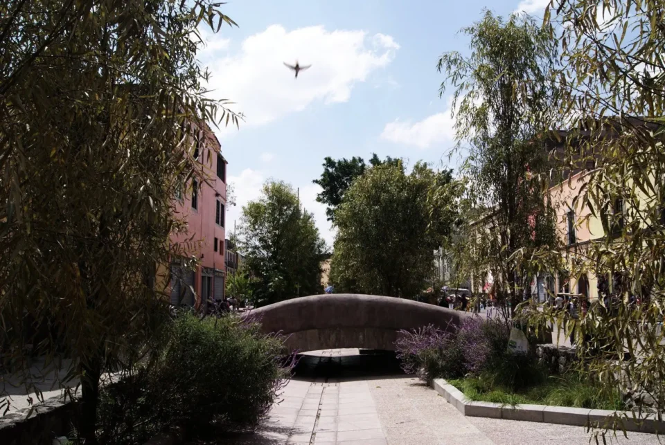
With this event, it seems that the chapter of the waterways in the Historic Center is concluded. However, Mexico City is still located in a lake basin, and the power of the water that remains in its foundations sometimes manifests itself, reminding us of its past.
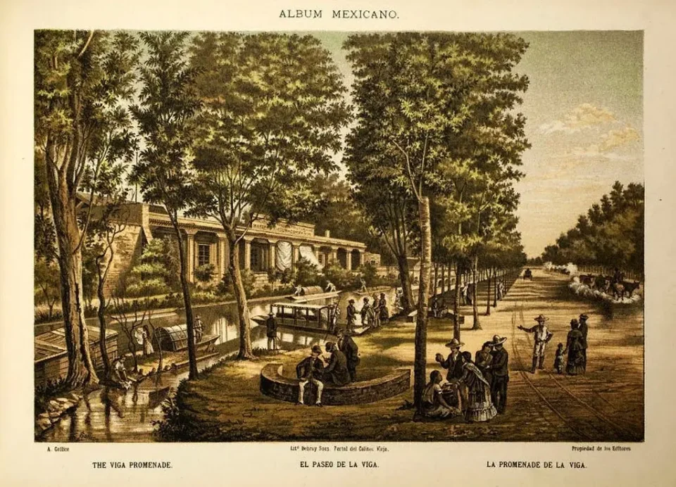
The Flowery Lenten Season and the Paseo de la Viga
A segment of the La Viga canal was transformed at the end of the 18th century into the charming Paseo de la Viga. Also known at different times as Paseo de la Orilla, Paseo de Revillagigedo, Paseo Juárez and Paseo de Iztacalco, it experienced its greatest splendor in the 19th century.
This place of recreation and entertainment for the inhabitants of Mexico City covered 1,560 meters long and 30 meters wide. Its natural beauty inspired several writers, including Guillermo Prieto, the Marquise Calderón de la Barca, Luis Castillo Ledón and Ignacio Muñoz, according to Araceli Peralta.
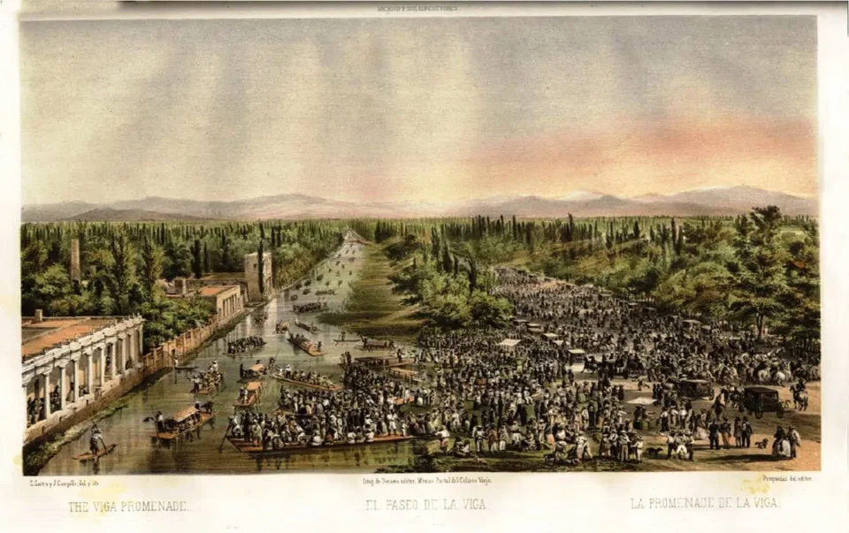
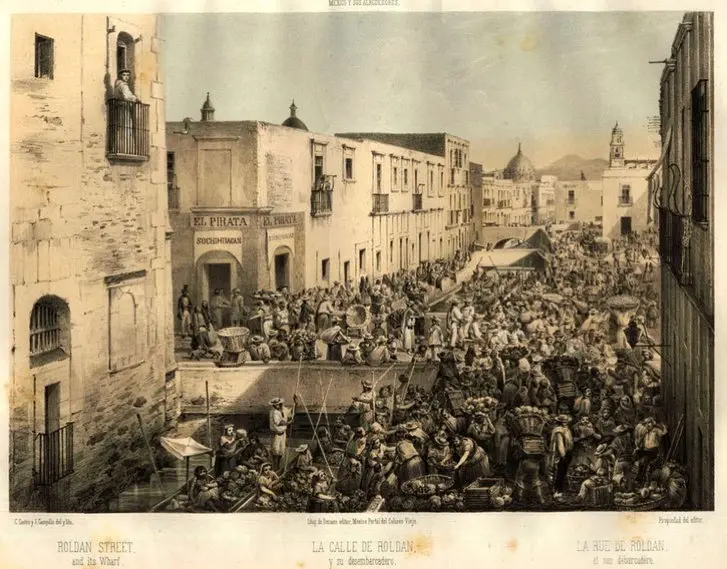
Especially during Lent and the celebration of the Friday of Sorrows, or Fiesta de las Flores, people of all social classes congregated at this site. Ignacio Muñoz, mentioned by Peralta, relates: “From early in the morning, the whole city would go to these streets (Roldán) where the pier was, renting canoes and trajineras decorated with poppies, celery, tulles and carnations, which were used to stroll along the canal until reaching La Viga or Santa Anita […] the rowers sang and danced in the canoes, where tamales, moles, atoles, enchiladas and all sorts of delicacies of the complex Mexican gastronomy were served.”
Xochimilca farmers took advantage of this festivity to earn additional income by offering rides in their canoes.
Incidents were not exempt, “mainly caused by drunkenness and negligence of visitors, which led the City Council to establish a mounted police force in charge of maintaining order in the promenades of Mexico City”.
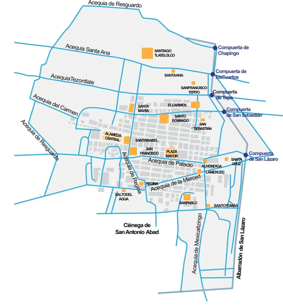
Acequias in Mexico City.
During the 18th century, there were five main irrigation ditches in Mexico City that originated in the western part of the Mexico Basin and crossed the region in a west-east direction, following the natural slope of the terrain until they flowed into Lake Texcoco, the lowest area. According to Guadalupe de la Torre Villalpando’s research, these irrigation ditches were fundamental to the hydraulic structure of the city.
Among these irrigation ditches were the Santa Ana, Tezontlale, the Apartado or del Carmen, another unspecified one that entered through the Chapultepec Causeway (filling the neighborhoods of San Juan and Belén), and then turned south, crossing the Salto del Agua and Monserrat neighborhoods until it reached the San Antonio Abad swamp. The Royal or Palace irrigation ditch was the largest and most abundant, divided into three branches, including the Regina and La Merced.
Additionally, there was the outstanding Mexicaltzingo acequia or La Viga canal, which arose to the south, in Chalco, and continued its course northward, passing through the east of the city. Another significant acequia was the resguardo (fiscal) or “square ditch”, so called because of its distinctive shape. It was begun in the first half of the century with the purpose of connecting the sentry boxes that surrounded the city, facilitating better control of tax collection and the entry of merchandise. Although it was never completed in its entirety, the sections that were built gradually disappeared due to urban expansion at the end of the 19th century.
These irrigation ditches played a vital role in the historical configuration of Mexico City, and although many of them are no longer visible, their legacy endures and continues to influence the structure of the city today.
–