This time we are going to see the description of the acequias canals and aqueducts of Mexico City a little more in detail and one by one, to understand more about how they worked and what was their route.
These are the most important irrigation ditches that were part of Mexico City.
Santa Ana-Santa Isabel Ditch
The name of this distinguished ditch did not originate, as is often presumed, in homage to a Most Serene Highness, but by virtue of one of its branches that flowed north of the venerable temple of Santa Ana Atenantitech. From the crossroads of Flores Magón, this water current flowed southward, crossing the area of Eje Central, where several notable bridges were erected.
Among them were the Puente de las Guerras (where it branched into two arms), the Puente de los Angeles, the Puente de Santa Maria, the Puente del Zacate (also known as Peru), the Puente de Villamil, the Puente Juan Carbonero and the famous Puente de la Mariscala, located on Hidalgo Avenue, right in front of the Convent of Santa Isabel, today known as the majestic Palacio de Bellas Artes.
Following its course, this irrigation channel crossed the San Francisco Bridge (located at the intersection of Juárez and Madero) and culminated at the Hospital Real Bridge, located at the intersection of Venustiano Carranza and Artículo 123, where it ended, joining its flow with the Acequia Real. It also marked the northern limits that divided the city from Santiago Tlatelolco, through a branch that entered to the east, winding through the neighborhoods of Peralvillo and Tepito along Matamoros Street.
The bridges that crossed this ditch include the Santiago Bridge (formerly known as Allende), the Tecolotes Bridge (known as Comonfort), the Santa Ana Bridge (located in Peralvillo) and the Chirivitos Bridge (located in Jesús Carranza).
Subsequently, it merged with the Acequia de Zorrilla before reaching its final destination at the Compuerta de Tepito. Unfortunately, however, in the year 1882, this venerable acequia was sealed, marking the end of its historical legacy in the city.
San Pedro and San Pablo Ditch
An ancient watercourse that flowed from Tezontlale and connected with the Acequia del Carmen arouses our historical curiosity. This stream of water, after crossing the convent in a southerly direction, meandered gracefully between the buildings until it reached Girón, where it crossed over the iconic San Sebastián (formerly known as Bolivia) and Cuervo (renamed Colombia) bridges. At its final crossing, it took a turn to the west and ended at the San Pedro and San Pablo Bridge, marking the limits of the Colegio Máximo at that time.
This narrative transports us back in time, revealing the intricate network of irrigation ditches that once irrigated the city, and how these historic waterways shaped its urban landscape.
Acequia del Carmen
South of Tezontlale, we discovered the fascinating Acequia del Carmen, named in honor of its proximity to the plaza of the Convent of the Barefoot Carmelites. This riverbed emerged from the west, along Violeta Street, and then, after crossing Santa María at the point where the Zacate Bridge stands, continued its path along República de Perú, right in front of Plaza de Montero, a short distance from Plaza del Jardín (later known as Garibaldi) and the vibrant neighborhood of La Lagunilla.
Following the direction from west to east, the current Republic of Peru was composed of different segments such as Cerca de San Lorenzo, Espalda de la Misericordia, Puerta Falsa de Santo Domingo, Pulquería de Celaya and Apartado. Along its route, it crossed under several notable bridges such as the Misericordia Bridge (also known as Allende), the Santo Domingo Bridge (identified as Brazil), the Leguísamo Bridge (called Argentina) and the Carmen Bridge (known as Carmen-Aztecas).
Further on, after passing by the old Apartado building, which today houses the National Numismatic Museum, I arrived in front of the Convent del Carmen square, which was famous for its fountain and the statue in honor of Miguel Hidalgo, although today this space is occupied by the Abraham Castellanos Elementary School, next to another wide square called La Concordia. Continuing towards the east, it crossed the Cantaritos Bridge (renamed Torres Quintero-Florida), located in the modern Manuel de la Peña y Peña, and a few hundred meters further on it reached the San Sebastián Gate.
It is important to note that the section that extended from Santa María to the Carmelite convent was sealed in 1794, and ninety-two years later, the eastern segment of the irrigation ditch also suffered the same fate. This story allows us to appreciate the rich history that lies in the bowels of the city.

Tezontlale Ditch (Tezontle, Tezontlali)
The historic Acequia de Tezontlale (also known as Tezontle or Tezontlali) flowed majestically from west to east, winding through the city of yesteryear. Its course took it between two cemeteries that no longer exist, Santa Paula to the south and San Andrés to the north, in the picturesque neighborhood of Santa María la Redonda-Cuepopan. This water serpentine crossed the renowned Calzada de Santa María (known today as Eje Central), changing its name to Puente de las Guerras (Bridge of Wars) at the crossing with the irrigation ditch, in commemoration of the bridge that was erected over it. Later, the ditch entered the city through Calle de Órgano, passing under the iconic bridges: Puente del Clérigo (also known as Allende) and Puente de los Esquiveles (called Carrizo-Comonfort), to then join Eje 1 Norte in the vicinity of Puente de Tezontlale (today known as República de Brasil). On its way, it passed through the Callejón de los Puentecitos (today known as Callejón Ecuador) and crossed the Puente Blanco located on Calle del Relox (today Argentina), right in the current location of the Porrúa Bookstore, near the majestic Templo Mayor.
Upon reaching the point where Ecuador Street became Costa Rica, right in front of the current Granaditas Market, the irrigation ditch entered a scarcely urbanized area, at least until the middle of the last century. At the corner of Florida Street, it merged with the Acequia de Zorrilla. Unfortunately, however, in 1882, the flow of Tezontlale was interrupted, marking the end of an important part of the city’s history.
Monserrat Ditch (Monserrate, Montserrat)
Emerging a few meters from the corner of Toribio-Cruz Verde (known as Izazaga) and Monserrate (at Isabel la Católica), was the enigmatic Acequia we want to talk about. This very ancient waterway entered the southern indigenous periphery through an alley that unfortunately has disappeared over time.
Its route took it to cross Nezahualcóyotl Street, joining Isabel la Católica Road, in the middle of the settlements of San Salvador el Seco to the west and San Salvador el Verde to the east. After crossing the Carretones Bridge, the irrigation ditch took a turn to the southeast and entered the Rinconada de la Chinampa (a street that has been forgotten with the creation of Fray Servando), located within the neighborhood of El Verde.
Its route continued until it reached Necatitlan (on today’s 5 de Febrero), near Tlaxcoaque, where it joined the Acequia de Xoloc-Chimalpopoca-San Antonio Abad, which in turn connected with the Acequia de Roldán to the east. During the rainy season, this area was transformed into a vast chinampera swamp, reminding us of the importance of water management in the history of the city.
In addition to the Acequia de la Merced-Regina, other acequias played fundamental roles in the urban fabric. The non-navigable Acequias were part of the colossal project known as the Zanja Cuadrada, a late novo-Hispanic construction designed in part for fiscal and defensive purposes.
These ditches included that of San Diego, which alternated between canal and ciénega, and was notorious for being the place where the ashes of those executed by the Inquisition were thrown. There were also those in the neighborhoods of Niño Perdido and Candelaria de los Patos, which were home to these migratory birds, as well as the Acequia de Santa Veracruz and the lateral ditches that delimited the Paseo de Bucareli.
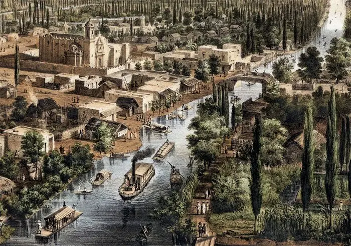
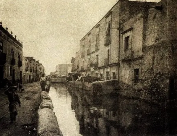
The irrigation ditches were late witnesses of the ancient lacustrine features of this metropolis, whose understanding cannot ignore its profound relationship with water. Their disappearance not only meant the loss of commercial, urban and road elements, but also the disappearance of identifying features of the neighborhoods and their inhabitants, whose origins date back to the 14th century. However, sometimes, during the rainy season, the water returns to flood the sidewalks and streets, reminding us that the city still holds in its heart a nostalgia or fear for its aquatic past.
Acequia de la Merced-Regina
One of the historic “interior” irrigation ditches that ran through Mexico City was the Merced-Regina, whose origin was at the southern end of the Acequia de Santa Isabel. This water channel traced a meandering route through the streets and neighborhoods of the city, leaving its mark on the urban fabric.
Starting on Zuleta Street, the irrigation ditch took a turn to the southeast, crossing blocks and emerging on Ortega Street (today known as Uruguay). Then, it passed through the corner where the Puente Quebrado (Salvador) Bridge used to stand, connecting with Ratas (Aldaco) Street and continuing towards the corner of Mesones and Bolívar. It reached Regina, near the Convent of Regina Coeli, and advanced almost to the corner of Tornito de Regina-San Jerónimo, ending its route at the Puente del Monzón (Isabel la Católica), where the Casa de la Acequia is located today.
At this crucial point, three irrigation ditches intertwined: the Merced, the Chapitel (heading west) and the Monserrat (heading southeast). The Merced irrigation ditch followed its course northeast towards the Merced neighborhood, crossing Isabel la Católica Street and entering the bridges of Aduana Vieja (5 de Febrero and Regina), de Jesús (located on Mesones, almost on the corner with Pino Suárez, in front of the hospital of the same name), Balvanera (on Correo Mayor, on the corner with Salvador) and then entering the properties between the Correo Mayor-Las Cruces block. Finally, it reached the corner of Puerta Falsa de la Merced (Uruguay) and Fierro Street (Jesús María, a few meters from the Convent of La Merced and the temple of San Pablo).
The irrigation ditch continued its course eastward in a straight line along Uruguay Street until it reached the Santiaguito Bridge, where it met the Roldán irrigation ditch. A few blocks away, between Uruguay and Manzanares, the canal entered again between the houses, crossing the alley of Santo Tomás to reappear in Manzanares, in front of the church of Señor de la Humildad. Its route continued northeast, winding through the houses and crossing the Rosario Bridge (at the corner of Corregidora and Rosario) until it reached its final destination at the Zanja Cuadrada (in Congreso de la Unión), south of the Garita and the Compuerta de San Lázaro.
This story allows us to appreciate the complex network of irrigation ditches that once crossed the city, leaving their mark on its historical development.
–